Depths of Dankai Part 3
Following on from last week, we're in the middle of the Tajikistan Pamir mountains, finding a route around the west side of Lake Karakul. We're getting close to Dankai, which might be waist deep, or over our heads.
***
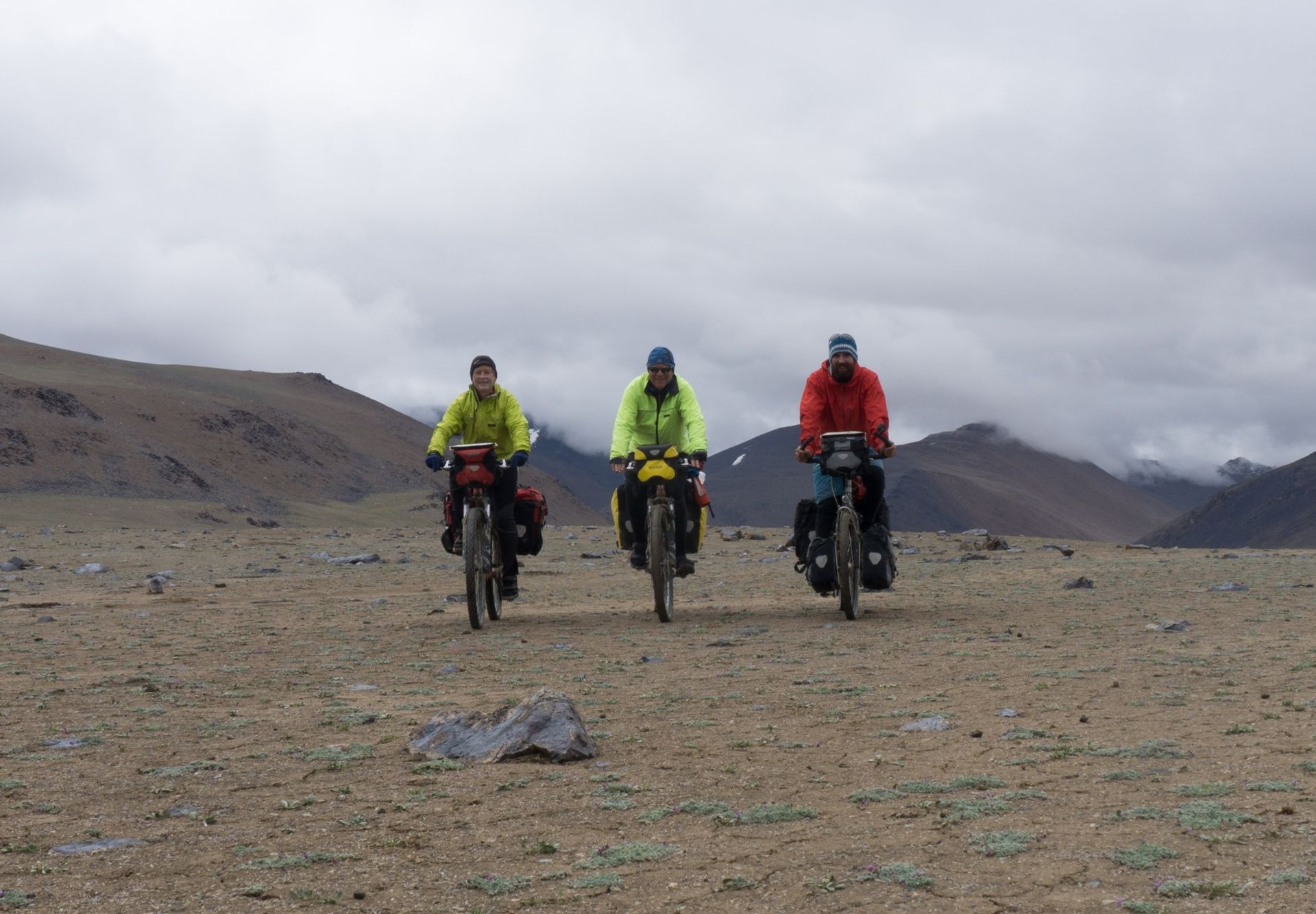
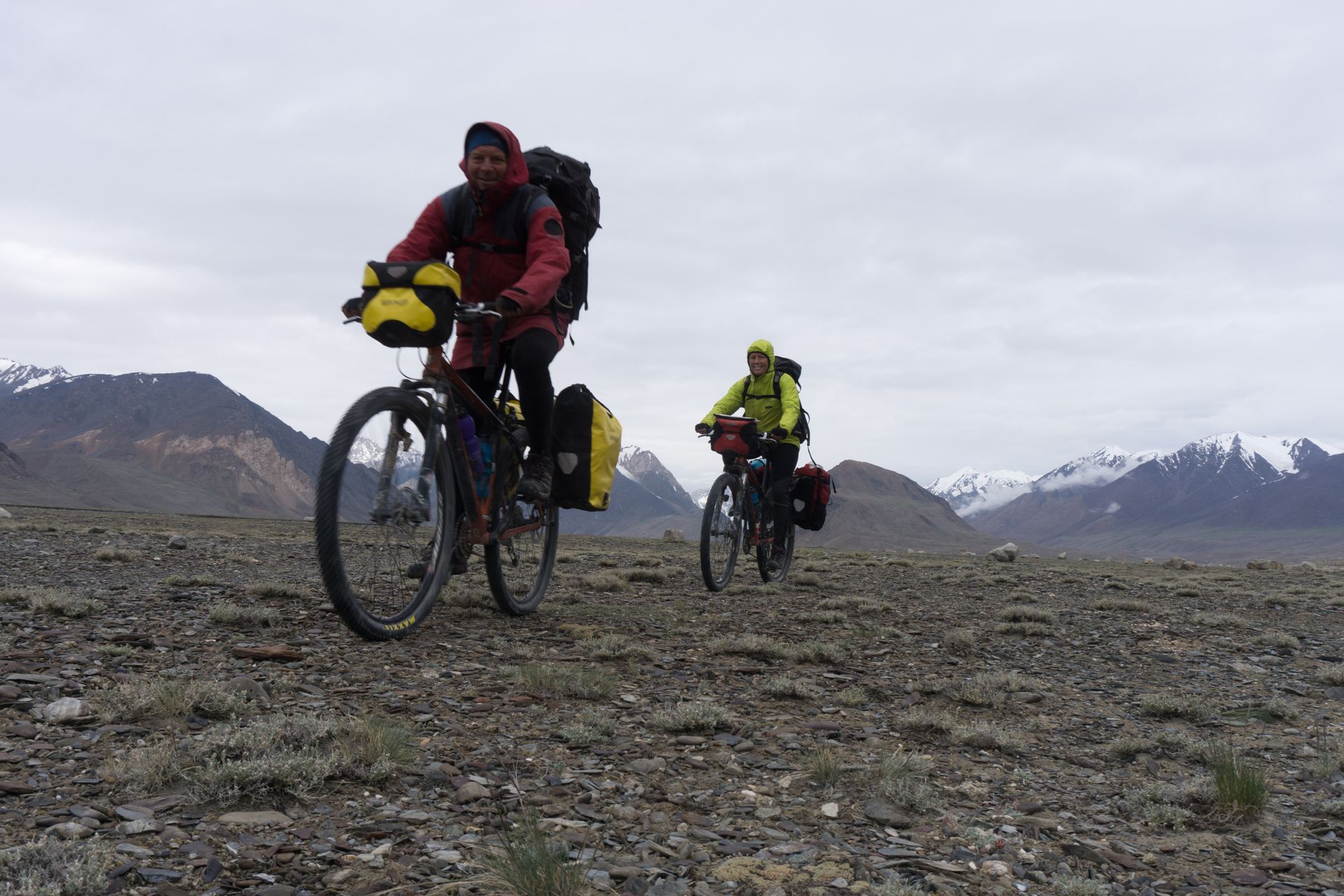
The track peters out again on the way to Karachym Pass but the mostly gravelly surfaces means we keep cycling. We've been riding at over 4000m above seal level for weeks so our lungs are practised at pulling all the oxygen out of the air and our red blood cells have bulked up to grab every molecule. We take a break to take pictures with the self-timer on Michael's camera. During our photo shoot, an olive-green jeep roars towards us and a man wearing an olive cap, dark green jersey and camo pants jumps out. We are in a National Park and we owe park fees – he waves papers at us after ripping their newspaper cover off and tossing them on the dirt.
"Yes, yes." We nod and smile, sign in the boxes he points to, and hand over Tajik somonis to the value of about five New Zealand dollars each. The ranger puts our money in a cash box, jumps back in his jeep and accelerates off in the direction of Jia Lo.
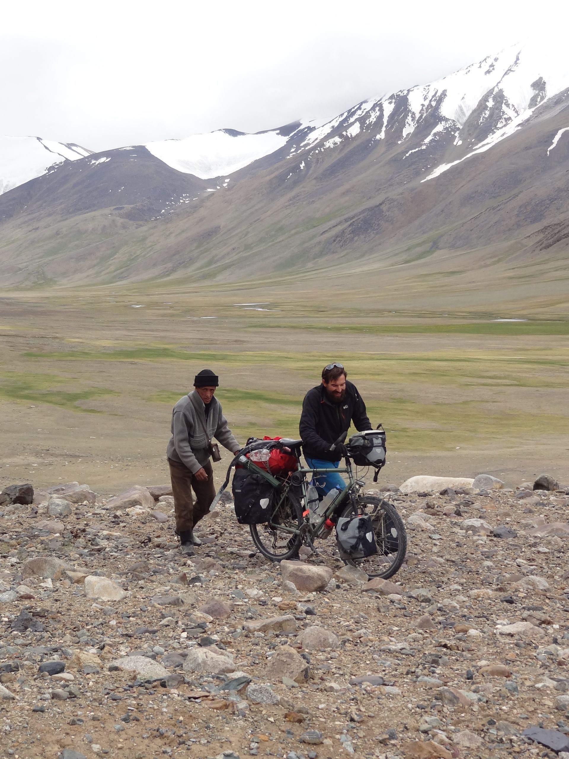
We cycle until the steepening gradient reduces us to pushing. Every hundred steps I rest and marvel at the bleakness and beauty of the mountains. A shepherd slides out of the rocky landscape, camouflaged by his grey woolen sweater, chocolate brown trousers. He has binoculars slung over his shoulder in a leather case that looks like my grandad's. The shepherd's head is kept warm by a black felt hat with a brim like a cake tin and a four-seamed centre sitting neatly on his crown. He runs up behind Michaels bike and pushes on Michael's carrier to help him climb to the pass. When we reach the top, we offer the shepherd an oreo biscuit from our packet but he shakes his head. Is food so precious you don't take someone else's?
From the pass we look out to a wide floodplain several hundred metres below us. More brown and grey slopes either side of the floodplain taper up into snow capped by clouds. We can't see the Dankai confluence – no clues yet on how deep the crossing might be. Chris and Michael leap on their bikes and take off down the slope, veering between rounded boulders. I yell, "Do you want to break your bike?" We're two days ride from the road and they're risking broken spokes?
Soon, cycling is impossible for all of us because we cross a knee deep cascade back and forth, following steeply dropping animal tracks, manoeuvring our bikes over soft earth and between boulders which are now metre-scale. "Let's hope we aren't coming back," I say. "No way we can push our loaded bikes uphill."
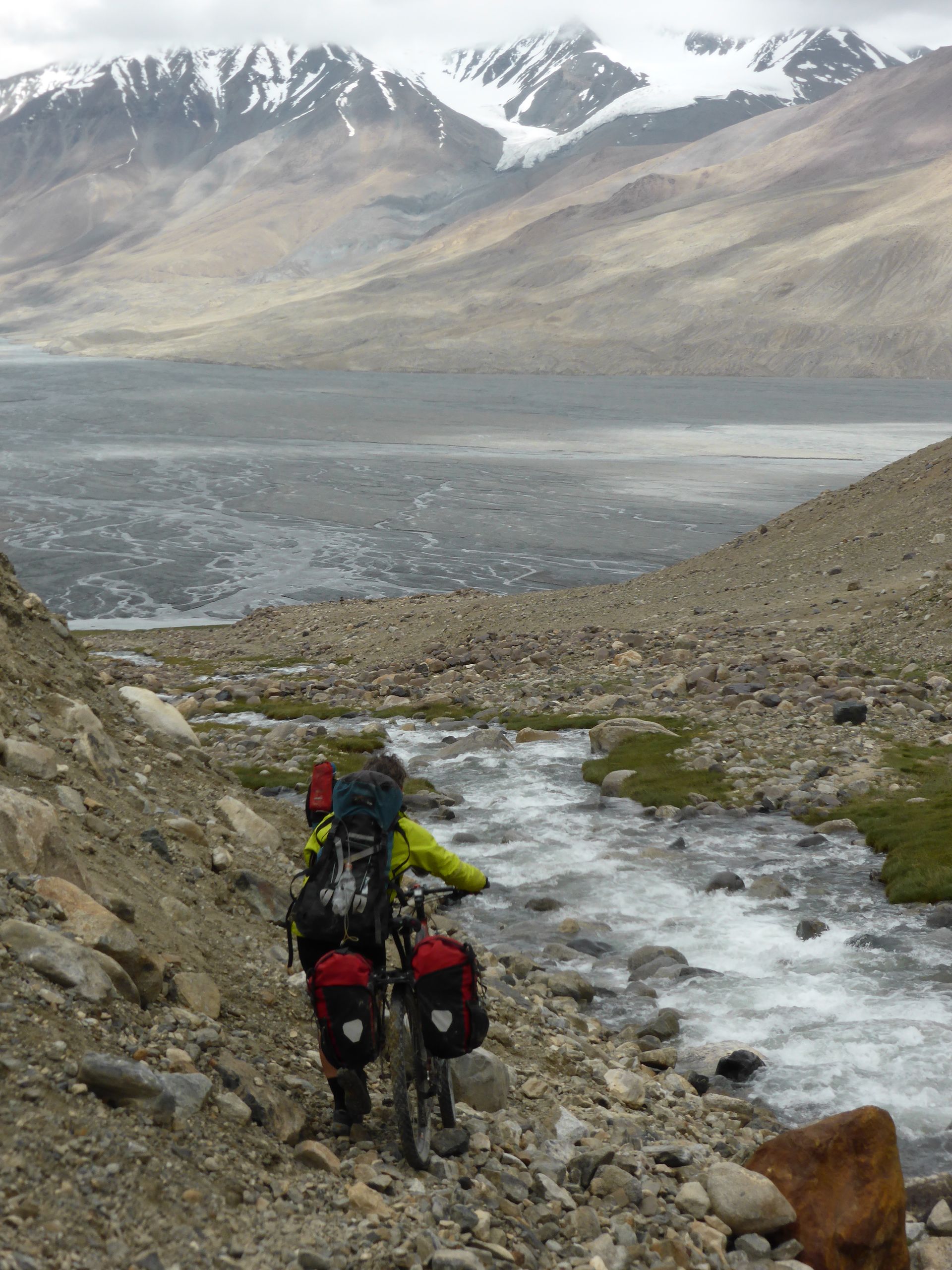
Dankai gradually appears below us – we can see the edge of the body of water with an uncountable number of braids feeding into it. I shut down the thinking part of my brain and concentrate on wheeling my bike without damaging it or myself. When we reach the edge of Dankai at 1pm, sun is breaking through the clouds. I'll take it as a good omen.
"Let's have some lunch," I say. We stop to eat on the edge of the two hundred metre-wide stretch of milky-grey water. None of us talk much – I assume we're all thinking about how deep the water might be and the steep descent that brought us down to Dankai. Chris keeps his helmet on – for more warmth? Or because he's too tired to take it off?
When we can't delay any longer, Chris says, "I'll test it. I'm the heaviest." He and I have had far more experience of fording rivers then Michael, coming from New Zealand where many tramping trips start and end with crossing a river. The majority of people who die in the New Zealand back country drown in rivers. They reach a flooded river and want to get to the hut on the other side, or back to their car and home for work the next day. So they cross when logic should have told them to stay out of the water.
What constitutes a bad idea in Tajikistan? Attempting a river crossing because it will take a day or more to climb back up to a pass and we only have two more days of food? However, the water is flowing very slowly and there no rapids visible downstream; surely the worst that can happen is Chris goes for a swim then we have to put up our tents and get warm in our sleeping bags?
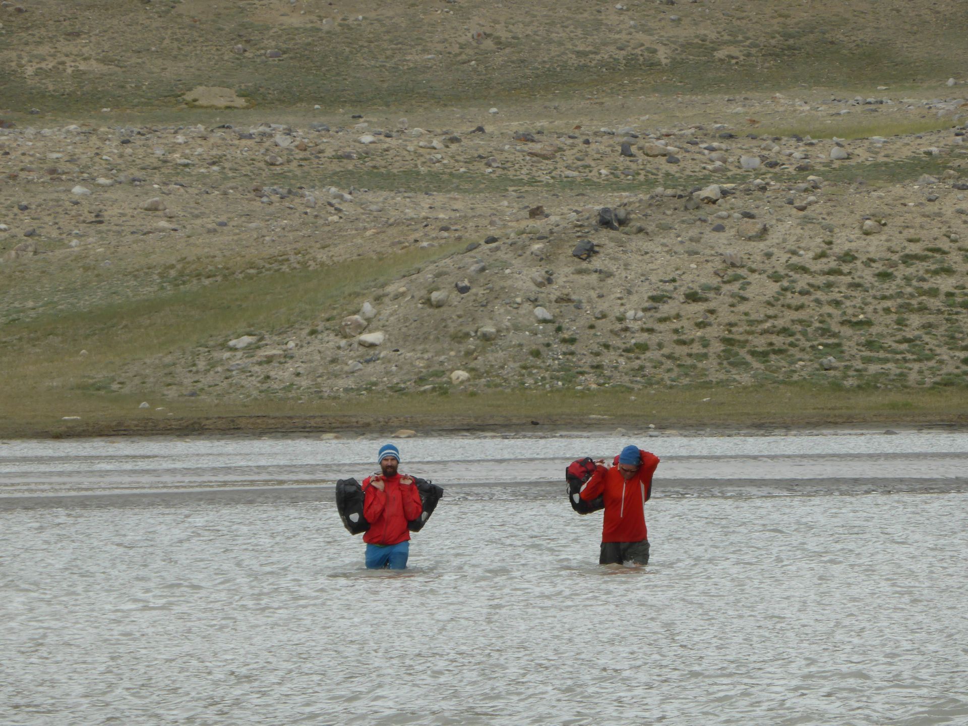
Chris peels off his leggings, puts on shorts, pulls on his pack and fills it to the brim with food from his panniers – hoping to hold himself down if the current is strong? He wades slowly into the flow. "It's not too cold," he calls at the water reaches his knees. Halfway across we see him wave a thumbs up as his upper legs start to appear from water which, at its highest, only reached his waist.
Chris's waist, my lower chest. I take off clothes in preparation for getting wet as Chris wades back to us and Michael removes his panniers. "It wasn't bad," Chris says. "A few soft places but no actual quicksand."
Quicksand? I hadn't contemplated that possibility! Might there be quicksand Chris didn't find? I tighten the straps on my cycling sandals to keep them on my feet.
The three of us load up with packs and panniers across and I walk ahead to take photos from the far bank of two men in orange shirts and blue beanies commenting on what happens when glacier-water gets to the level of your testicles. Then Michael and Chris do another round of ferrying with bicycles balanced on their shoulders. As we put our warm clothes back on, we grin at one another – we've crossed the broadest part of the flow. "Good one!" "Well done!" We exchange high fives.
The cloud is dropping again and misty rain starts to fall as we reload our bikes and cycle across the flood plain we saw from Karachym Pass. This is easy, it won't take long until we reach the other side of the river. We might be nearly there. I start thinking of cups of tea and hot soup.
Except we are not there yet. Now river braids form a continuous barrier of dark grey water of indeterminate depth running far more rapidly than in our first crossing. We are moving into lack of logic territory – it's mid afternoon, it's raining, we can see the other side of the valley, we've nearly conquered Dankai.
Braid by braid we progress. Ankle deep braids. Calf deep braids. Then a ten metre wide braid where we stop and stare. "What do you think?"
"Hopefully not too deep?" Chris says. "I'll give it a go."
He walks slowly into the flow, balancing at each step and feeling with his feet. The grey swirls only reach his knees but he wobbles in the current. "We'll need two on a bike to get through," I say.
Michael and Chris hold the bikes, one on the front, one on the back. I'm always keen for a challenge but today I'm happy to be a photographer; I'm the lightest by tens of kilos, as well as tens of centimetres shorter with my centre of gravity much closer to river level. The bike tyres try to float and the bikes twist sideways, pullings against Michael and Chris's grips.
Then the river releases us. No more braids; compact gravel. We pedal to the edge of the plain, put up our tents and put on our warm clothes. "I'll lie down for a few minutes," Chris says and burrows into his sleeping bag in the tent. Michael and I fire up our MSR multi-fuel stoves that sound like small jet planes. We cook spaghetti with packets of tomato soup and an onion given to us by the Jia Lo yak-herders. Chris asks for his dinner in bed; he's shattered.
Michael and I need to do the dishes so we won't have tomato-flavoured breakfast. We strike out across the gravel towards the river braids, rather than wasting the filtered water in our bottles. We walk and we walk some more and we wonder what can have happened to the river. We are fifteen minutes away when we hear what sounds like rolling rocks. We turn to see a herd of ibex run past the tents, then a second herd run by.
"Lucky Chris, he got to see ibex up close," I say. We have seen few animals other than yak herds although we have passed lots of ibex and Marco Polo sheep horns on the ground. Pamir ibex are a hunting specialty, along with Marco Polo sheep. I wish I could see a Marco Polo sheep though seeing ibex is a lot better than nothing.
After twenty minutes, Michael and I finally reach a trickle of water in the gravel. "This is the river?" Michael says, looking upstream, as if the river might be hiding behind a boulder.
"It's glacial." My geologist brain kicks into gear and I remember a glacier melt-fed stream will run high during the day. We likely crossed at peak flow; something we should have considered in our Dankai expedition. What else might we have missed about the route? I’m hoping the last day is going to be straightforward, given how tired Chris seems.
Next episode next week...
Get new content delivered
directly to your inbox.
Latest Posts